
There are no specific hours for this county-owned property which is not managed as a park
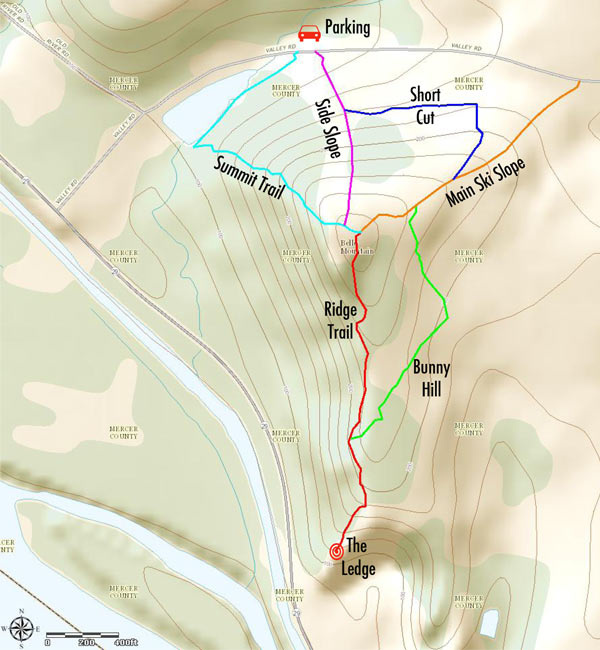
(609) 989-6559 Website Google Maps Belle Mountain Trail Map
Gravitas: ![]() Hiking:
Hiking: ![]() Proximity:
Proximity:![]()
In this era of global warming, it seems crazy that Mercer County could have leased a mountain to a ski resort operator. But a ski facility did operate here between 1965 and 1997. Now the place is pretty much ignored, which is a pity, because it’s truly beautiful and provides highly entertaining hiking to experienced, adventurous types. If you’re comfortable walking on paths that aren’t maintained and aren’t blazed, you can discover some of the most exciting hiking and best views to be found anywhere in the immediate area. And it’s only 25 minutes from downtown!
Warning: While this land is open to the public, the trails described in this review are NOT maintained by the Mercer County Parks Commission. You’ll be walking along a mix of paths worn by other hikers, old maintenance roads, and old ski trails which are reverting to fields and are irregularly mowed. The path to “The Ledge” is steep and narrow in parts, and takes you within a foot or two of sheer drops that could be fatal (and, for a few yards, with steep drop-offs on BOTH sides). It is also above the firing range used by County police and corrections officers. If you are even slightly acrophobic, or suffer from vertigo, this is NOT the trail for you. Avoid this area during prime tick season, as you will need to walk through heavy brush in places. Wear long pants and good hiking boots. Use of a hiking staff is recommended. Needless to say, you will be walking at your own risk.
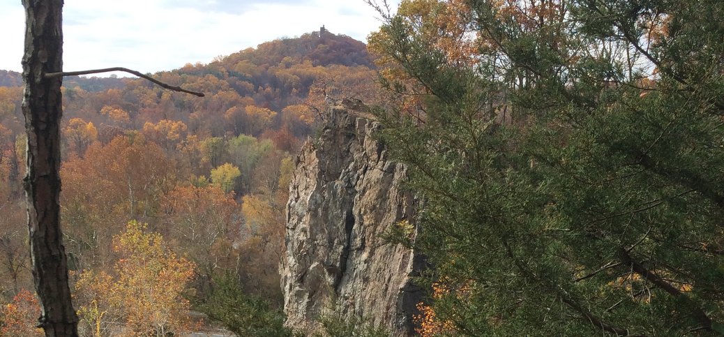
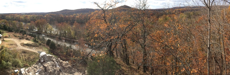
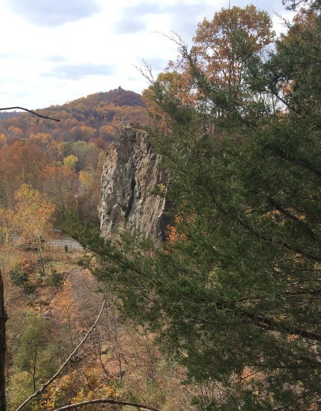
All the caveats aside, this is truly a fun hike with some of the BEST visual payoffs in Mercer County. You’ll see great views of the Delaware from “The Ledge” at the end of the Ridge Trail, and fabulous vistas of the Baldpate Ridge to the east from the summit and trails on the eastern side of the mountain. While the vertical climb is only 190 feet or so to the summit, the gradient is fairly steep. Along the Ridge Trail, the terrain undulates nicely, and is seriously steep in places, making the “wood-scapes” interesting (scroll down for image of trail map). Note, however, that this is a fairly short walk. If you’re fit, and don’t get lost, walking all of the “trails” won’t take more than about 45 minutes. You’re a very close drive to Goat Hill and Baldpate Mountain, however, so if you want a longer walk, you can easily combine an exploration of Belle Mountain with these other parks.
BTW, the ledge is the remnant of a quarrying operation by the “Mercer County Workhouse” which is now the “Correction Center”. On 29, just before you get to Valley Rd, you’ll pass a building that looks like a barn on concrete stilts. This was the old sorting operation, where crushed stone was separated into different size gravel. Just past this building, you can catch a quick view of the nearly vertical stone wall of the “Ledge” as you drive by.
It’s clear that some people have been enjoying these walks, “under the radar”, for many years. While it obviously doesn’t get a LOT of foot traffic, it’s enough to keep the paths visible (if you’re experienced enough to recognize them). I suggest parking at the gravel lot on Valley Road, and entering at the gate closest to the pond. Then walk along the far bank of the pond until you see a path heading up the hill. The path is pretty much straight up the fall-line, until you near the summit and run into what were probably service roads for the ski area. The “game trail” we’ve labeled the “Ridge Trail” is pretty easy to spot heading south from the summit, and I had no difficulty following it (ignoring faint trails that appeared to descend back towards Rt. 29 in places).
Definitely not for the faint of heart, this hiking gave me an adrenaline rush. How many places in Mercer County can do that?


Note that as of September 2019 the trails are completely overgrown with brambles. Access to the ledge is restricted with no trespassing signs everywhere. The signs say this is because of the law enforcement firing range at the base of the ledge.
Sad.
I learned to ski there!
Awww yesssss……
This is beautiful…
Gotta find out where this is…
Looks beautiful … picture worthy.
Belle Mountain (A Mercer County Property), Valley Rd, Titusville, NJ 😉
My folks used to walk here every other day, years ago.
Perfect time of year
WOW, I never knew about this, they’ve hidden it very well.
Beautiful place ! A great place close by to visit .
Back in the 60’s & early 70’s there was a Boy Scout Camp somewhere in that area. It was used by the troops that were part of the George Washington Council. Anyone remember exactly where it was located?
Goat hill the state owns the property now. Its a park
Rex S is exactly right. If you go on the Hidden Trenton website and search for “Goat Hill”, you’ll find two reviews: one for the maintained trails there (beautiful, perfect for kids) and one for bushwhacking (with a GR series map that turns your smartphone into a GPS). If you bushwhack, you’ll tun into the odd remains of the boy scout camp
My wife and I were going to try the Switchback Trail today on Baldpate Mtn but it was closed for Deer Management. So instead we hiked up Belle Mtn at your suggestion. We went straight up on what you call the Side Slop and then the Ridge Trail. We then bush wacked as far as we could go to what I think was the Ledge on our right and a closed parking lot below us on our left. I don’t think we made it to your Ledge as we weren’t on any narrow trails with a drop off on either side.
We then headed back down to the right on what I assume was your “Bunny Hill” and “Main Ski Slope” and then cut back on your “Short Cut” under the small hand held ski lift.
I don’t think we made it to you “Ledge”. Any further hints? The total hike was about 50 mins.
Thanks for letting us all know about this area.
*****
Editor’s Comment: I’ve been back a few times since I wrote the review. The “ridge trail” can, at times, be indistinct. There are also often two paths, one lower, one higher. That said, if you take one of the lesser paths you can run into dead ends. Often the paralleling alternate is only a few feet away, and you’ll see faint tracks up or down to merge back with it. It sounds like you were close to the “ledge” but certainly you would know it if you got there. It’s on top of an quarry face, and the drop is straight down on the south side.
The key to tracking the ridge trail is that it roughly parallels the river/29. With the leaves down you’ll see the road off your right shoulder. There ARE definitely paths through the brush, you just have to find them. Then you get to a point where the N-S ridge ends. The ledge is off to the right, now following a ridge that is taking you towards the river/29.